


On October 14, 1957, a little known disaster occurred in the Spanish city of Valencia. When I first moved to Valencia in 2005, I heard the story of the Turia (the Valencia river) flooding the city in the 1950’s. Now, the city has the beauty of a park in place of the dry riverbed. Years after I first moved to Spain, I decided to research the event in more depth (excuse the pun), and it is the backdrop for my second Secrets of Spain novel, Vengeance in the Valencian Water (out Jan. 2014).
In my first book of the series, Blood in Valencian Soil, Cayetano, a bullfighter from Madrid and Luna, a bike mechanic from Valencia, team up to find the burial-place of a murdered Republican soldier and his involvement with an International Brigade nurse, who disappeared from Cuenca in 1939. The second book of the series, while on the search for more civil war mass graves, Cayetano’s Falange member grandfather, José, is forced to tell his story of survival during the Valencian flood which changed his life forever.
 The Turia wasn’t always a flowing torrent of water. While there has been recorded flood records since the 1300’s, the riverbed spent most of its time dry, where people would walk to the tiny stream to wash their clothes. Shack houses sprung up in the riverbed. Sales of animals were held down in the riverbed. It was not a year round flowing river. Serious floods had happened every century that the modern city was based against the Turia, the most recent in only 1949 when several dozen people drowned. Even so, they were unprepared for October 1957.
Before you read on, here is the link to a documentary made in 2007 by Valencia University, with radio reports, video footage and eyewitness accounts of the flood. It’s all in Spanish, but if you don’t speak the language, you could just mute the sound and watch the video if you want, you will get the idea. Floods pretty much speak for themselves.
Each October, rain comes to the Valencia region, not so much in the city area, but in the surrounding plains and mountainous area that separates the city from inland Spain (If you’re new to this area, Valencia is both a city and a province of Spain. Just a heads-up). The rainfall surges during this change in autumn, onto land that is very dry after a long year without much rain. On Saturday 12 October, 1957, the heavens opened up over Valencia city, in conjunction to the torrential rains in surrounding villages in the Turia (plains around the city) region. On the morning of Sunday 13 October, Las Provincias newspaper noted that the outlying towns of Lliria, Segorbe, Chelva, Requena and Buñol had received rainfall of 500 millimetres in only two days. The Barranco del Carraixet and Palancia rivers north of the city, and the Magre river to the south, along with the Turia river through than ran Valencia city had all risen, but said there was no reason to worry. The rain began to die down in the city, and by late evening, had stopped completely. What the people of Valencia didn’t know was the immense torrent that was gushing its way down the Turia river towards them.
At around 9.30pm, an emergency call came through from the towns of Pedralba and Vilamarxant, 40 kilometres from Valencia, announcing that both towns had been flooded by a deluge of water as the river swelled beyond breaking point. At 11pm, an alarm sounded in the city, notifying all Guardia Civil and Police to be on alert, as the flood was heading directly towards the populated city.
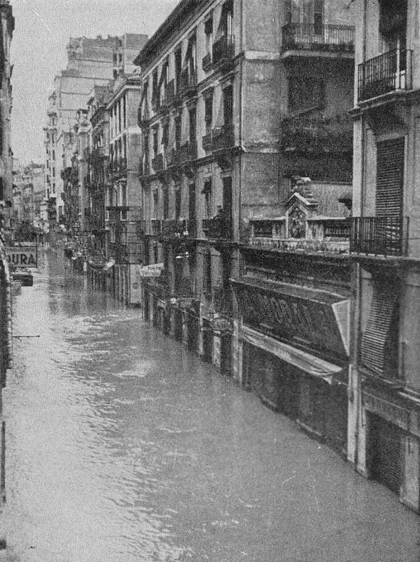
Just after midnight, with the absence of rain, the river continued to swell, and logs and debris began floating through the city, blocking the bridges that connected the two sides of Valencia. Alarms sounded to alert people, and messengers knocked on doors in the El Carmen and Campanar areas, both the closest barrios on each side of the river’s edge. Radio messages went out with a flurry as police rushed to warn people of impending water. Soon after, the first waves began crashing over the edge of the riverbed, instantly flooding the flat streets on both sides, just as the torrential rains returned. In one hour, the water height pouring against the central city was between one to two metres and rising, cutting people off from any escape in the dark. More than 1000 cubic metes of water per second flowed into the streets, reaching over two metres in some areas. The Manises Dam at the edge of the city rose to seven metres above normal height as the river tripled its width and swallowed up much of the city and surrounding area. All water, power and phone connections were swamped and collapsed under the water. Reports say manhole covers exploded into the air followed by a violent shot of muddy water as the water took the city one street at a time.
 (If you don’t speak Spanish – blue: river, green: populated flooded farming areas, purple: city/town flooded, grey: not flooded populated areas. Notice the tiny safe area in the centre of the disaster zone?)


In the centre of the old town lies the Plaza de la Virgen and Plaza de la Reina, where today stands the Valencia cathedral, the Basilica and the archbishop’s palace just behind them. Along with Calle Micalet, this tiny pocket was once home to a mosque and before that a Roman city. This area is built on the slightest, and almost impossible to see, ridge in the land, resulting in these treasures not getting any water and instead were surrounded. (Coincidentally, in my novel, the main character lives one street over from Calle Micalet in this magical pocket of space, but don’t be fooled into thinking they are all going to be safe – you know I don’t write happy endings!)
At 4am, the flood reached its peak of approximately 2,700 cubic metres of water per second, but then quickly tapered off. As the sun rose on Monday October 14, the water continued to decrease and the Manises dam was no longer inundated. From the peak of around eight metres above average to only two metres at the dam, Valencians thought the worst was over. A single telephone line to Castellon in the north remained, so emergency services could get word to Madrid, calling for help. All roads and rail lines leading out of the city towards Madrid, Barcelona and Albacete were blocked, damaged or completely swept away. Many of the bridges that crossed the Turia were damaged or destroyed, along with the beautiful stonework that lined the river one day earlier.
 As people ventured out into the water and mud-filled streets, the government received a message around midday that things were about to get worse. The towns of Pedralba to Vilamarxant had again been inundated with a second flood, washing away all landmarks. The water took two hours to reach Valencia city, with 3,500 cubic meters of water per second hitting around 2pm, accompanied by the worst downpour of rain yet seen; around 100 millimetres in just half an hour, enough that people couldn’t even see in front of them. By 3.30pm, the flood reached its peak of around 6,000 cubic metres of water per second, enough to start washing away buildings that had been weakened in the first flood. The river had expanded to cover 2,200 hectares. While Valencia city gave many the luxury of multi-story buildings to find shelter above the water line, which rose between two to five metres above street level in places, the more outlying areas by the beach and port, including the towns of Nazaret, El Cabanyal and Malvarrosa at the mouth of the river, were on flat land and single level buildings, resulting in a complete catastrophe and loss of life as the water poured into the sea. Only five bridges, the longest-standing stone ones, remained in place, though some were damaged and impassable. The worst had finally passed, and the riverbed emptied out into silence again. The final death toll was recorded as 81, though the actual figure remains unknown, but commonly thought around 400.
 In the coming days, the army came in by truck and helicopter, bringing up to 500,000 kilos of bread to feed stricken residents. Many needed to be airlifted from rooftops and isolated pockets of dry land as the water receded. Much of the city, port and beach areas were filled with a heavy mud and debris, resulting in a ‘on hands on deck’ response from army and locals alike to clean up. On October 24, dictator Francisco Franco arrived (when much was cleaned already, of course) to survey the damage and have his loyal (oppressed, whatever) subjects cheer for him for coming to the disaster zone. As people lived on bread brought north from Gandia and milk given out by the ladle-load, the long process of rebuilding began. The mud was not completely cleaned away until the end of November.


In June 1958, the outlying port and beach areas suffered a second minor flood, as their drains were still clogged with mud, and the following month ‘Plan Sur’ began, a project to divert the river. The plan had initially been designed over a decade earlier but sidelined due to excessiveness (which is ironic considering the ‘excessiveness’ of everything the Valencian government spends money on). A plan to build an enormous green space in the city was put up against building a huge highway to get people from Madrid to the beach a fraction faster. In 1965 construction began to divert the river south of the city, resulting in water flowing around the city for the first time in 1972. At the same time, land cleared by the flood on the other side of the river from the old town was used to create many new buildings, mostly apartments, giving Valencia a construction boom (that’s a whole other tale). The flood had accidentally given Valencia a whole new chapter in its story, already thousands of years old. (I have never seen any water in the river diversion, other than the tiny part where the sea flows into the river mouth. If you have a photo of the Plan Sur river diversion (any year) with water in it, I would love to see it).
Here is a short clip (in Spanish) made as they designed Plan Sur in the 60’s, with some aerial shots of Valencia if you’re so inclined.
In 1976, on his first visit to Valencia as head of State, King Juan Carlos I gifted the dry riverbed to the city, and the highway plan was shelved forever; the seven kilometre park won its place in Valencia’s history. Construction on the final part of the Turia riverbed park continues today, with most of the park now complete. The ‘top’ of the park has Valencia’s zoo, the Bioparc, and footpaths and bike lanes weave though gardens, streams, sports fields, playgrounds to the other end, home to Valencia’s massive Arts and Sciences complex. The final part, where the old riverbed meets the sea is all-but completed.
While Valencia is an amazing city, the park is the jewel in the crown.


This is a tourism video was taken a few years ago, but shows Valencia from the air, over the park and areas rebuilt after the flood, plus many of the great sights you can read about in my books.

All photos in 1957 are courtesy of Juan Antonio Soler Aces.
